
Addis Abeba topographic map
Interactive map
Click on the map to display elevation.
About this map
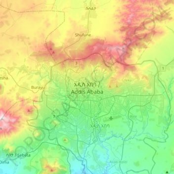
Name: Addis Abeba topographic map, elevation, terrain.
Average elevation: 2,517 m
Minimum elevation: 2,058 m
Maximum elevation: 3,383 m
Addis Abeba hat eine Fläche von etwa 530 km². Die nahezu im Mittelpunkt Äthiopiens befindliche Stadt liegt zwischen 2200 und 3000 Metern Höhe am Fuße des Bergs Entoto und ist damit die dritthöchstgelegene Hauptstadt der Welt und die höchstgelegene in Afrika.