
Punturin topographic map
Interactive map
Click on the map to display elevation.
About this map
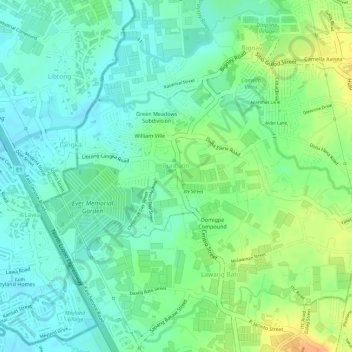
Name: Punturin topographic map, elevation, terrain.
Location: Punturin, Valenzuela, Metro Manila, 1447, Philippines (14.72977 120.97667 14.74443 120.99805)
Average elevation: 16 m
Minimum elevation: 2 m
Maximum elevation: 42 m
Other topographic maps
Click on a map to view its topography, its elevation and its terrain.
Malinta
Malinta, 1st District, Valenzuela, Northern Manila District, Metro Manila, Philippines
Average elevation: 8 m
Valenzuela
Valenzuela, Third District, Metro Manila, 1441, Philippines
Average elevation: 24 m
Malanday
Malanday, 1st District, Valenzuela, Northern Manila District, Metro Manila, 1444, Philippines
Average elevation: 4 m