
Kirkwall topographic map
Interactive map
Click on the map to display elevation.
About this map
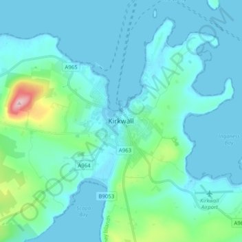
Name: Kirkwall topographic map, elevation, terrain.
Location: Kirkwall, Orkney Islands, Scotland, KW15 1DH, United Kingdom (58.94160 -3.00037 59.02160 -2.92037)
Average elevation: 27 m
Minimum elevation: 0 m
Maximum elevation: 225 m
Other topographic maps
Click on a map to view its topography, its elevation and its terrain.
North Ronaldsay
United Kingdom > Scotland > Orkney Islands
North Ronaldsay, Orkney Islands, Scotland, United Kingdom
Average elevation: 3 m
Scapa Bay
United Kingdom > Scotland > Orkney Islands > Kirkwall
Scapa Bay, Kirkwall, Orkney Islands, Scotland, United Kingdom
Average elevation: 20 m
Lamb Holm
United Kingdom > Scotland > Orkney Islands
Lamb Holm, Orkney Islands, Scotland, KW17 2SF, United Kingdom
Average elevation: 3 m
Hoy
United Kingdom > Scotland > Orkney Islands > Rackwick
Hoy, Rackwick, Orkney Islands, Scotland, United Kingdom
Average elevation: 58 m
Links of Noltland
United Kingdom > Scotland > Orkney Islands > Pierowall
Links of Noltland, Noup Road, Pierowall, Orkney Islands, Scotland, KW17 2DQ, United Kingdom
Average elevation: 16 m
Orkney Islands
United Kingdom > Scotland > Orkney Islands
Orkney Islands, Scotland, United Kingdom
Average elevation: 9 m