
Les Bruyères topographic map
Interactive map
Click on the map to display elevation.
About this map
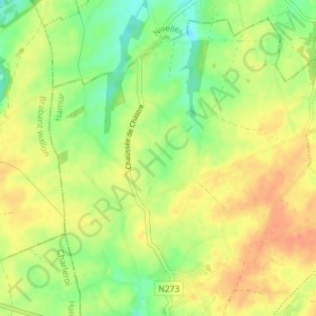
Name: Les Bruyères topographic map, elevation, terrain.
Location: Les Bruyères, Sombreffe, Namur, Wallonie, 5140, Belgique (50.53189 4.57605 50.57189 4.61605)
Average elevation: 155 m
Minimum elevation: 133 m
Maximum elevation: 173 m
Other topographic maps
Click on a map to view its topography, its elevation and its terrain.
Château de Sombreffe
Belgique > Namur > Namur > Sombreffe
Château de Sombreffe, Rue du Château, Sombreffe, Namur, Wallonie, 5140, Belgique
Average elevation: 151 m