
Fairmount topographic map
Interactive map
Click on the map to display elevation.
About this map
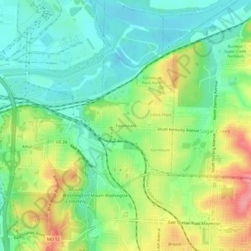
Name: Fairmount topographic map, elevation, terrain.
Average elevation: 247 m
Minimum elevation: 214 m
Maximum elevation: 300 m
Other topographic maps
Click on a map to view its topography, its elevation and its terrain.
Englewood
United States > Missouri > Jackson County > Independence
Englewood, Independence, Jackson County, Missouri, 64052, United States
Average elevation: 271 m
Maywood
United States > Missouri > Jackson County > Independence
Maywood, Independence, Jackson County, Missouri, 64054, United States
Average elevation: 273 m