
Make a donation
Cerro Tiro topographic map
Click on the map to display elevation.
Make a donation
About this map
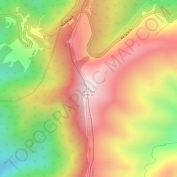
Name: Cerro Tiro topographic map, elevation, terrain.
Location: Cerro Tiro, Sabanilla, Zamora, Zamora Chinchipe, Ecuador (-4.00214 -79.14477 -4.00204 -79.14467)
Average elevation: 2,692 m
Minimum elevation: 2,285 m
Maximum elevation: 2,989 m
Make a donation
Other topographic maps
Click on a map to view its topography, its elevation and its terrain.
Zamora
Ecuador > Zamora Chinchipe > Zamora
Zamora, también conocida como Zamora de los Alcaides, es una ciudad ecuatoriana; cabecera del cantón Zamora y capital de la provincia de Zamora Chinchipe, así como la urbe más grande y poblada de la misma. Se localiza al sur de la Región amazónica del Ecuador, en los flancos externos de la cordillera…
Average elevation: 2,077 m