
Make a donation
Clear Spot Lookout topographic map
Click on the map to display elevation.
Make a donation
About this map
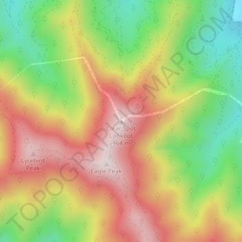
Name: Clear Spot Lookout topographic map, elevation, terrain.
Location: Clear Spot Lookout, Alpine Shire, Victoria, Australia (-36.75772 146.93588 -36.75762 146.93598)
Average elevation: 718 m
Minimum elevation: 416 m
Maximum elevation: 1,007 m
Make a donation
Other topographic maps
Click on a map to view its topography, its elevation and its terrain.
City of Melbourne
Melbourne's topography is characterized by a diverse landscape that transitions from flat coastal plains to rolling hills and mountainous regions. The city is situated at the northern end of Port Phillip Bay, where the terrain is predominantly flat, facilitating urban development. As one moves eastward, the…
Average elevation: 18 m
Melbourne
Melbourne is also prone to isolated convective showers forming when a cold pool crosses the state, especially if there is considerable daytime heating. These showers are often heavy and can include hail, squalls, and significant drops in temperature, but they often pass through very quickly with a rapid…
Average elevation: 185 m
Make a donation
Collingwood
Collingwood's topography is mostly flat, but a prominent slope extends from Hoddle Street up to Smith Street, and also along sections of Hoddle Street.
Average elevation: 30 m
Make a donation
Make a donation
Castlemaine
The Castlemaine goldfields' legendary prosperity raised expectations of Castlemaine becoming Victoria's second city. That is reflected in imposing buildings erected in the town's first few years. Though the rich alluvial diggings were largely exhausted within 15–20 years causing the town's population to…
Average elevation: 319 m
Mount Buller
Due to its far south-western location in the alpine region, Mount Buller is more susceptible to cold airmasses which allow it to record some of the lowest maximum temperatures and daytime readings in the country, despite being considerably lower in elevation than other mountain sites to the north-east. On 5…
Average elevation: 824 m
Make a donation
Bairnsdale
A comprehensive geological survey of Victoria's Great Dividing Range reveals a distinct north-south alignment in its bedrock, a vestige of the bygone epochs of plate tectonics. This enduring geological framework, coupled with ongoing tectonic activity, contributes to the dynamic topography witnessed in the…
Average elevation: 25 m
Frankston
Olivers Hill is the most prominent elevation in Frankston which rises to 55 metres above sea level (180 feet) at its highest point in the suburb. Its origins date to approximately 415 to 360 million years ago. Its base is Mount Eliza Granite dating from the Devonian period, which was covered in lava tuffs in…
Average elevation: 40 m
Make a donation
Make a donation
Dandenong Ranges National Park - Ferntree Gully
Australia > Victoria > Montrose
The topography consists of a series of ridges dissected by deeply cut streams. Sheltered gullies in the south of the range are home to temperate rain forest, fern gullies and Mountain Ash forest Eucalyptus regnans, whereas the drier ridges and exposed northern slopes are covered by dry sclerophyll forest of…
Average elevation: 345 m
Make a donation
Fitzroy
Australia > Victoria > Melbourne
Fitzroy's topography is flat. It is laid out in grid plan and is characterised by a fairly tightly spaced rectangular grid of medium-sized streets, with many of its narrow streets and back lanes facilitating only one-way traffic. Its built form is a legacy of its early history when a mixture of land uses was…
Average elevation: 35 m
Make a donation
Make a donation
Grampians National Park
Mount William is known within the gliding community for the "Grampians Wave", a weather phenomenon that sometimes enables glider pilots to reach extreme altitudes of the order of 28,000 ft (8,500 m). This predominantly occurs during the months of May, June, September and October when strong westerly winds flow…
Average elevation: 262 m
Make a donation
Make a donation
Make a donation
Make a donation
Make a donation
Make a donation
Make a donation
Make a donation
Oakleigh South
Australia > Victoria > Melbourne
A 2005 report called Livable Melbourne that was commissioned by The Age and conducted by Tract Consultants and ACIL Tasman, ranked Melbourne suburbs and assigned them scores on fourteen characteristics such as crime, CBD proximity, and traffic congestion. The report found that Oakleigh South had a very low…
Average elevation: 55 m
Lilydale-Warburton Rail Trail
Australia > Victoria > Melbourne > Woori Yallock
Average elevation: 105 m
Make a donation
Make a donation
Horsham
Horsham's topography is flat, approximately 128 metres (420 ft) above sea level. The central business district (CBD) is laid out in a grid plan south of the train line and is characterised by wide streets and several roundabouts. Firebrace Street, running north–south through the middle of the CBD is one of…
Average elevation: 129 m
Make a donation
Templestowe
Australia > Victoria > Melbourne
Gentle, rolling hills extend from east of the Yarra River flood plains, along Templestowe Road (towards the Eastern Freeway) for seven km (4.3 miles), to the north-east. The altitude of the plain above sea level is 50 m, and the topography is subdued and mostly flat; the hills are just below 60 m, the slopes…
Average elevation: 66 m
Make a donation
Omeo
There are bus routes from Bright and Bairnsdale. The Bairnsdale bus runs weekdays, once both directions, and the Bright bus (Alps Link) timetable is less frequent in Summer and runs additional services during the ski season. Alps Link is the highest altitude public bus in Australia. The town sits at the…
Average elevation: 861 m
Make a donation
Make a donation
Port Phillip
Port Phillip's mostly flat topography and moderate waves make perfect conditions for recreational swimming, kitesurfing, windsurfing, sailing, boating, snorkeling, scuba diving, stand up paddle boarding (SUP) and other sports.
Average elevation: 18 m
Make a donation
Toolangi
Toolangi has a cold rainforest climate, significantly cooler and wetter than Melbourne due to elevation (of 595 metres) and being outside of the Yarra rainshadow; with annual cloud cover resembling that of Southern England in the British Isles and the Pacific Northwest of North America, more than the typical…
Average elevation: 562 m
Make a donation