
Thank you for supporting this site ❤️
Make a donation
Make a donation
Bhati Kalan topographic map
Click on the map to display elevation.
Thank you for supporting this site ❤️
Make a donation
Make a donation
About this map
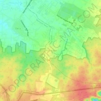
Name: Bhati Kalan topographic map, elevation, terrain.
Location: Bhati Kalan, Saket Tehsil, South Delhi District, Delhi, India (28.40701 77.17056 28.44701 77.21056)
Average elevation: 281 m
Minimum elevation: 248 m
Maximum elevation: 315 m
Thank you for supporting this site ❤️
Make a donation
Make a donation
Other topographic maps
Click on a map to view its topography, its elevation and its terrain.
The Garden of Five Senses
India > Delhi > Saket Tehsil > Saidulajaib Extension
Average elevation: 242 m