
Loscos topographic map
Interactive map
Click on the map to display elevation.
About this map
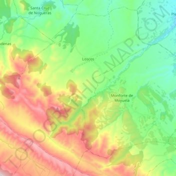
Name: Loscos topographic map, elevation, terrain.
Location: Loscos, Jiloca, Teruel, Aragón, España (41.00589 -1.14930 41.11717 -0.98959)
Average elevation: 1,054 m
Minimum elevation: 810 m
Maximum elevation: 1,468 m
Other topographic maps
Click on a map to view its topography, its elevation and its terrain.
Navarrete del Río
España > Aragón > Jiloca > Calamocha
Navarrete del Río, Calamocha, Jiloca, Teruel, Aragón, 44200, España
Average elevation: 962 m
San Martín del Río
San Martín del Río, Jiloca, Teruel, Aragón, España
Average elevation: 878 m
Ojos Negros
Ojos Negros, Jiloca, Teruel, Aragón, España
Average elevation: 1,178 m
Monreal del Campo
Monreal del Campo, Jiloca, Teruel, Aragón, 44300, España
Average elevation: 993 m