
Copper Hill topographic map
Interactive map
Click on the map to display elevation.
About this map
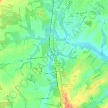
Name: Copper Hill topographic map, elevation, terrain.
Average elevation: 55 m
Minimum elevation: 37 m
Maximum elevation: 82 m
Other topographic maps
Click on a map to view its topography, its elevation and its terrain.
Reaville
United States > New Jersey > Hunterdon County > Raritan Township
Reaville, Raritan Township, Hunterdon County, New Jersey, United States
Average elevation: 52 m
Rockefellows Mills
United States > New Jersey > Hunterdon County > Raritan Township
Rockefellows Mills, Raritan Township, Hunterdon County, New Jersey, 08822, United States
Average elevation: 46 m