
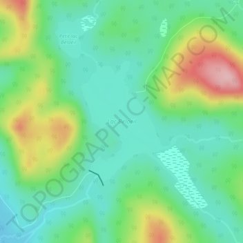
Lac Beloeil topographic map
Interactive map
Click on the map to display elevation.
About this map
Name: Lac Beloeil topographic map, elevation, terrain.
Average elevation: 866 m
Minimum elevation: 810 m
Maximum elevation: 987 m
Other topographic maps
Click on a map to view its topography, its elevation and its terrain.
Lac Monaham
Canada > Québec > Charlevoix > Lac-Pikauba
Lac Monaham, Lac-Pikauba, Charlevoix, Capitale-Nationale, Québec, Canada
Average elevation: 893 m
Parc national des Grands-Jardins
Canada > Québec > Charlevoix > Lac-Pikauba
Parc national des Grands-Jardins, Lac-Pikauba, Charlevoix, Capitale-Nationale, Québec, Canada
Average elevation: 815 m
Mont du Gros Ruisseau
Canada > Québec > Charlevoix > Lac-Pikauba
Mont du Gros Ruisseau, Lac-Pikauba, Charlevoix, Capitale-Nationale, Québec, Canada
Average elevation: 493 m
Lac Grelon
Canada > Québec > Charlevoix > Lac-Pikauba
Lac Grelon, Lac-Pikauba, Charlevoix, Capitale-Nationale, Québec, Canada
Average elevation: 817 m