
Thank you for supporting this site ❤️
Make a donation
Make a donation
Sint-Pieter topographic map
Click on the map to display elevation.
Thank you for supporting this site ❤️
Make a donation
Make a donation
About this map
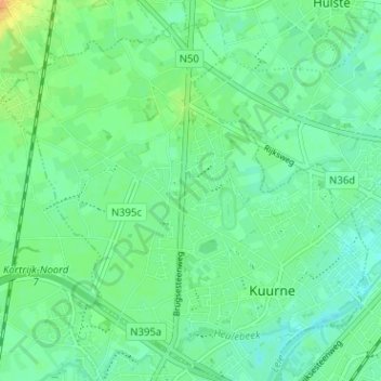
Name: Sint-Pieter topographic map, elevation, terrain.
Location: Sint-Pieter, Kuurne, Kortrijk, West-Vlaanderen, 8520, België (50.84219 3.25200 50.88219 3.29200)
Average elevation: 17 m
Minimum elevation: 7 m
Maximum elevation: 37 m
Thank you for supporting this site ❤️
Make a donation
Make a donation
Other topographic maps
Click on a map to view its topography, its elevation and its terrain.
Kuurne
België > West-Vlaanderen > Kortrijk > Kuurne
Kuurne ligt aan de Leie, welke ten behoeve van het scheepvaartverkeer werd rechtgetrokken. De Heulebeek mondt hier in de Leie uit. Het gebied van Kuurne heeft een hoogte van 12,5 tot 23 meter. Het gebied van Kuurne is dicht bebouwd, met enkel in het noordwesten nog open gebied. Naast de Heulebeek stromen nog…
Average elevation: 17 m