
Make a donation
Allevard topographic map
Click on the map to display elevation.
Make a donation
Allevard
The commune has a ski resort: the Collet d'Allevard which is located 10 km from the town (30 minutes drive). The altitude of the runs varies from 1,450m to 2,100m. The resort has 35 km of runs: 7 green, 6 blue, 5 red, and 3 black.
Make a donation
About this map
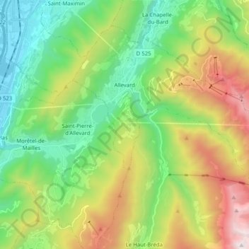
Name: Allevard topographic map, elevation, terrain.
Average elevation: 983 m
Minimum elevation: 238 m
Maximum elevation: 2,400 m
Make a donation
Other topographic maps
Click on a map to view its topography, its elevation and its terrain.
Make a donation
Lac de Paladru
France > Auvergne-Rhône-Alpes > Isère > Paladru
The lake area has a cool temperate climate. The north–south orientation and relatively high altitude means the average temperature is around 10 °C. Rainfall is irregular, with most rain occurring in June and October with the rise of humid air masses from the Mediterranean. January is the coldest month, with…
Average elevation: 569 m
Make a donation
Make a donation
Make a donation
Hameau des Farlaix
France > Auvergne-Rhône-Alpes > Isère > Autrans-Méaudre en Vercors > Méaudre
Average elevation: 1,155 m
Les Brunières
France > Auvergne-Rhône-Alpes > Isère > Saint-Quentin-sur-Isère
Average elevation: 423 m
Make a donation
Uriage Les Bains
France > Auvergne-Rhône-Alpes > Isère > Saint-Martin-d'Uriage
Average elevation: 618 m
Roche Béranger
France > Auvergne-Rhône-Alpes > Isère > Chamrousse
The road to the ski station starts at Uriage-les-Bains from where the climb is 19 km (12 mi) long, gaining 1,235 m (4,052 ft) in elevation, at an average gradient of 6.5%. There are several sections in excess off 11% in the early stages of the climb. For the Tour de France, the summit is at an elevation of…
Average elevation: 1,561 m
Make a donation
Make a donation
Make a donation
Make a donation
Pic du Lac Blanc
France > Auvergne-Rhône-Alpes > Isère > Le Freney-d'Oisans
Average elevation: 2,912 m
Make a donation
Les Beauches
France > Auvergne-Rhône-Alpes > Isère > Le Sappey-en-Chartreuse
Average elevation: 1,072 m
Make a donation