
Thank you for supporting this site ❤️
Make a donation
Make a donation
Perry topographic map
Click on the map to display elevation.
Thank you for supporting this site ❤️
Make a donation
Make a donation
About this map
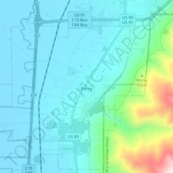
Name: Perry topographic map, elevation, terrain.
Location: Perry, Box Elder County, Utah, United States (41.43948 -112.07825 41.49162 -112.00572)
Average elevation: 1,429 m
Minimum elevation: 1,281 m
Maximum elevation: 2,261 m
Thank you for supporting this site ❤️
Make a donation
Make a donation
Other topographic maps
Click on a map to view its topography, its elevation and its terrain.
Hansel Mountains
United States > Utah > Box Elder County
Located in northeast Box Elder County, the southwest of the range abuts the Locomotive Springs State Wildlife Management Area; the northeast end of the range ends at a lower elevation divide between the North Hansel Mountains that lie on the Utah-Idaho border. Snowville lies on Deep Creek in the Sage Valley to…
Average elevation: 1,472 m
Thank you for supporting this site ❤️
Make a donation
Make a donation
Thank you for supporting this site ❤️
Make a donation
Make a donation