
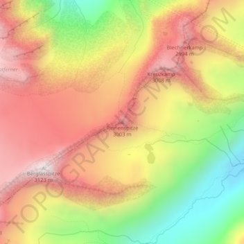
Rinnenspitze topographic map
Interactive map
Click on the map to display elevation.
About this map
Name: Rinnenspitze topographic map, elevation, terrain.
Average elevation: 2,666 m
Minimum elevation: 2,163 m
Maximum elevation: 3,072 m
Other topographic maps
Click on a map to view its topography, its elevation and its terrain.
Alpeiner Knotespitze
Österreich > Tirol > Bezirk Innsbruck-Land > Gemeinde Neustift im Stubaital
Alpeiner Knotespitze, Gemeinde Neustift im Stubaital, Bezirk Innsbruck-Land, Tirol, Österreich
Average elevation: 2,791 m
Kampl
Österreich > Tirol > Bezirk Innsbruck-Land > Gemeinde Neustift im Stubaital
Kampl, Gemeinde Neustift im Stubaital, Bezirk Innsbruck-Land, Tirol, 6166, Österreich
Average elevation: 1,337 m
Ruderhofspitze
Österreich > Tirol > Bezirk Innsbruck-Land > Gemeinde Neustift im Stubaital
Ruderhofspitze, Gemeinde Neustift im Stubaital, Bezirk Innsbruck-Land, Tirol, Österreich
Average elevation: 3,011 m
Scheibe
Österreich > Tirol > Bezirk Innsbruck-Land > Gemeinde Neustift im Stubaital
Scheibe, Gemeinde Neustift im Stubaital, Bezirk Innsbruck-Land, Tirol, 6167, Österreich
Average elevation: 1,411 m
Östlicher Elferturm
Österreich > Tirol > Bezirk Innsbruck-Land > Gemeinde Neustift im Stubaital
Östlicher Elferturm, Gemeinde Neustift im Stubaital, Bezirk Innsbruck-Land, Tirol, 6167, Österreich
Average elevation: 1,939 m
Forchach
Österreich > Tirol > Bezirk Innsbruck-Land > Gemeinde Neustift im Stubaital
Forchach, Gemeinde Neustift im Stubaital, Bezirk Innsbruck-Land, Tirol, 6167, Österreich
Average elevation: 1,461 m
Bärenbad
Österreich > Tirol > Bezirk Innsbruck-Land > Gemeinde Neustift im Stubaital > Forchach
Bärenbad, Forchach, Gemeinde Neustift im Stubaital, Bezirk Innsbruck-Land, Tirol, 6167, Österreich
Average elevation: 1,727 m