
Make a donation
Lombok topographic map
Click on the map to display elevation.
Make a donation
Lombok
The island's topography is dominated by the centrally-located stratovolcano Mount Rinjani, the second-highest volcano in Indonesia, which rises to 3,726 metres (12,224 ft), making Lombok the 8th-highest island. The most recent eruption of Rinjani occurred in September 2016 at Gunung Barujari. In a 2010 eruption, ash was reported as rising 2 kilometres (1.2 miles) into the atmosphere from the Barujari cone in Rinjani's caldera lake of Segara Anak. Lava flowed into the caldera lake, raising its temperature, while ash fall damaged crops on the slopes of Rinjani. The volcano and its crater lake, Segara Anak (child of the sea), are protected by the Gunung Rinjani National Park established in 1997. Recent evidence indicates an ancient volcano, Mount Samalas, of which now only a caldera remains, was the source of the 1257 Samalas eruption, one of the largest volcanic eruptions in recorded history, which caused worldwide changes in weather.
Make a donation
About this map
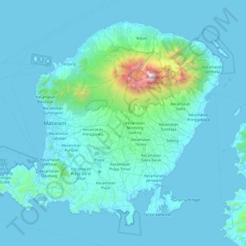
Name: Lombok topographic map, elevation, terrain.
Location: Lombok, West Nusa Tenggara, Lesser Sunda Islands, Indonesia (-8.95610 115.82120 -8.21031 116.72511)
Average elevation: 192 m
Minimum elevation: -1 m
Maximum elevation: 3,605 m
Make a donation
Other topographic maps
Click on a map to view its topography, its elevation and its terrain.
Rinjani
Indonesia > West Nusa Tenggara
In September 1995 an aviation report was issued concerning an unconfirmed ash cloud from Rinjani. A NOTAM about volcanic activity from Rinjani was issued by the Bali Flight Information Region on the morning of 12 September. An ash cloud was reportedly drifting to the south west with the cloud top around 4 km…
Average elevation: 3,071 m
Make a donation
Tambora
Indonesia > West Nusa Tenggara
Mount Tambora, or Tomboro, is an active stratovolcano in West Nusa Tenggara, Indonesia. Located on Sumbawa in the Lesser Sunda Islands, it was formed by the active subduction zones beneath it. Before the 1815 eruption, its elevation reached more than 4,300 metres (14,100 feet) high, making it one of the…
Average elevation: 1,393 m
Make a donation
Rinjani
Indonesia > West Nusa Tenggara
Mount Rinjani (Indonesian: Gunung Rinjani; Sasak: ᬕᬸᬦ᭄ᬗᬸᬂ᭞ᬭᬶᬦ᭄ᬚᬦᬶ, romanized: gunong rinjani) is an active stratovolcano situated in regencial North Lombok of West Nusa Tenggara province on the Indonesian island of Lombok. It reaches an elevation of 3,726 metres (12,224 ft),…
Average elevation: 3,071 m
Make a donation
Make a donation
Make a donation
Make a donation
Make a donation
Dusun Balekuwu
Indonesia > West Nusa Tenggara > Lombok Barat > Kecamatan Gunungsari
Average elevation: 34 m
Make a donation
Make a donation
Rinjani
Indonesia > West Nusa Tenggara
In September 1995 an aviation report was issued concerning an unconfirmed ash cloud from Rinjani. A NOTAM about volcanic activity from Rinjani was issued by the Bali Flight Information Region on the morning of 12 September. An ash cloud was reportedly drifting to the south west with the cloud top around 4 km…
Average elevation: 3,071 m
Dusun Teloke Laug
Indonesia > West Nusa Tenggara > Lombok Barat > Desa Senteluk
Average elevation: 46 m
Make a donation
Make a donation
Make a donation
Make a donation
Make a donation
Kota Subulussalam
Indonesia > West Nusa Tenggara > Lombok Tengah > Mertak Tombok
Average elevation: 87 m
Make a donation
Tambora
Indonesia > West Nusa Tenggara
Mount Tambora, or Tomboro, is an active stratovolcano in West Nusa Tenggara, Indonesia. Located on Sumbawa in the Lesser Sunda Islands, it was formed by the active subduction zones beneath it. Before 1815, its elevation reached more than 4,300 metres (14,100 feet) high, making it one of the tallest peaks in…
Average elevation: 1,393 m
Make a donation
Dusun Batu Layar
Indonesia > West Nusa Tenggara > Lombok Barat > Desa Batu Layar
Average elevation: 51 m
Make a donation