
Make a donation
Kangding topographic map
Click on the map to display elevation.
Make a donation
Kangding
Kangding has a monsoon-influenced climate, lying in the transition between a humid continental (Dwb) and a subtropical highland climate (Cwb) on the Köppen system. Despite the elevation of 2,560 metres (8,400 ft), the diurnal temperature variation averages at most 10.6 °C (19.1 °F) in any month. From April to September, rain is a very common occurrence, with around two-thirds of the days receiving some rainfall; in addition, 77% of the annual precipitation is delivered from May to September. Monthly daily average temperatures range from −1.9 °C (28.6 °F) in January to 15.7 °C (60.3 °F) in July; the annual mean is 7.29 °C (45.1 °F). Over the course of the year, the frost-free period lasts 177 days and there are 1,738 hours of sunshine. The highest temperature ever recorded in Kangding was a high temperature record of 30.1 °C (86.2 °F) measured on March 30, 2007.
Make a donation
About this map
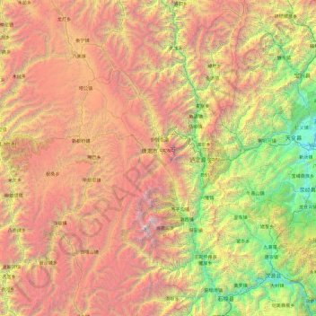
Name: Kangding topographic map, elevation, terrain.
Location: Kangding, Kardze, Sichuan, 626000, China (29.13707 101.00520 30.76818 102.49243)
Average elevation: 3,331 m
Minimum elevation: 658 m
Maximum elevation: 7,423 m
Make a donation
Other topographic maps
Click on a map to view its topography, its elevation and its terrain.
Make a donation
Jiuzhaigou
China > Sichuan > Jiuzhaigou County
The county consists of nine villages in a valley in Sichuan Province. The main ethnic group in the county is Han, with the second being Tibetan. The county seat has an altitude of about 1,400 m (4,600 ft). It has a total area of 2,041 square miles (5,286 km2). As of 2015, the county's total population was…
Average elevation: 2,520 m
Make a donation