
Brussel topographic map
Interactive map
Click on the map to display elevation.
About this map
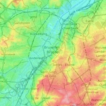
Name: Brussel topographic map, elevation, terrain.
Location: Brussel, Brussel-Hoofdstad, Brussel Hoofdstad, België (50.79641 4.33546 50.89050 4.40201)
Average elevation: 56 m
Minimum elevation: 10 m
Maximum elevation: 121 m
Other topographic maps
Click on a map to view its topography, its elevation and its terrain.
Grote Markt
België > Brussel-Hoofdstad > Brussel
Grote Markt, Centrumwijk, Vijfhoek, Brussel, Brussel-Hoofdstad, Brussel Hoofdstad, 1000, België
Average elevation: 42 m
Warandepark
België > Brussel-Hoofdstad > Brussel
Warandepark, Vijfhoek, Brussel, Brussel-Hoofdstad, Brussel Hoofdstad, 1000, België
Average elevation: 53 m
Zavel
België > Brussel-Hoofdstad > Brussel
Zavel, Vijfhoek, Brussel, Brussel-Hoofdstad, Brussel Hoofdstad, 1000, België
Average elevation: 53 m