
Make a donation
Pasacao topographic map
Click on the map to display elevation.
Make a donation
Pasacao
It covers an area of approximately 149.54 square kilometres (57.74 sq mi). The municipality is characterized by flat lowlands in the north and east, consisting of silt, and mountainous regions in the west. The western area mainly features rolling hills that are part of the highlands surrounding the Ragay Gulf, with the terrain primarily consisting of limestones, sandstones, and marls. The town's topography is characterized by steep slopes, with elevations ranging from sea level to over 400 metres (1,300 ft) above sea level. The highest point in the town is Mount Bernacci, which stands at 756 metres (2,480 ft) above sea level.
Make a donation
About this map
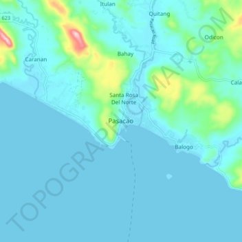
Name: Pasacao topographic map, elevation, terrain.
Location: Pasacao, Camarines Sur, Bicol Region, Philippines (13.47021 123.00115 13.55021 123.08115)
Average elevation: 31 m
Minimum elevation: 0 m
Maximum elevation: 279 m
Make a donation
Other topographic maps
Click on a map to view its topography, its elevation and its terrain.
Make a donation
Make a donation
Make a donation
Make a donation
Make a donation
Nabua
Nabua has about 8,803.0600 hectares or 99.42% very low elevation or less than 100 meters elevation and remaining 51.3593 hectares or 0.58% of low elevation or between 100 and 300 meters elevation. Its slope covers about 7,927.3616 hectares or 89.53% which are level to nearly level (0-3%) while the remaining…
Average elevation: 27 m
Make a donation
Mount Isarog
Philippines > Camarines Sur > Consocep
Mount Isarog is an active stratovolcano located in the province of Camarines Sur, Philippines, on the island of Luzon. The mountain has active fumaroles and hot springs. It has an elevation of 2,011.6 m (6,600 ft) above mean sea level.
Average elevation: 671 m
Make a donation
Make a donation