
Chelles topographic map
Interactive map
Click on the map to display elevation.
About this map
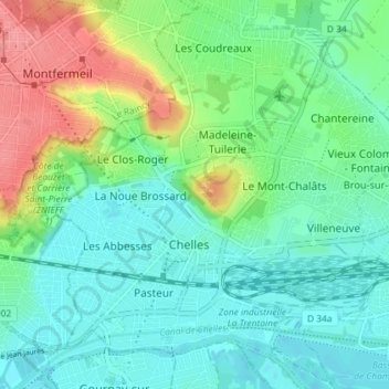
Name: Chelles topographic map, elevation, terrain.
Average elevation: 60 m
Minimum elevation: 35 m
Maximum elevation: 124 m
Other topographic maps
Click on a map to view its topography, its elevation and its terrain.
Noisy-le-Grand
France > Île-de-France > Seine-Saint-Denis > Gournay-sur-Marne
Noisy-le-Grand, Gournay-sur-Marne, Le Raincy, Seine-Saint-Denis, Île-de-France, France métropolitaine, France
Average elevation: 78 m