
Rettigheim topographic map
Interactive map
Click on the map to display elevation.
About this map
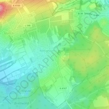
Name: Rettigheim topographic map, elevation, terrain.
Average elevation: 163 m
Minimum elevation: 125 m
Maximum elevation: 239 m
Other topographic maps
Click on a map to view its topography, its elevation and its terrain.
Tairnbach
Deutschland > Baden-Württemberg > Rhein-Neckar-Kreis > Mühlhausen
Tairnbach, Mühlhausen, Verwaltungsverband Rauenberg, Rhein-Neckar-Kreis, Baden-Württemberg, Deutschland
Average elevation: 205 m