
Melrose Township topographic map
Interactive map
Click on the map to display elevation.
About this map
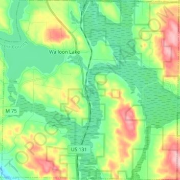
Name: Melrose Township topographic map, elevation, terrain.
Location: Melrose Township, Charlevoix County, Michigan, United States (45.20334 -84.97767 45.29155 -84.85395)
Average elevation: 238 m
Minimum elevation: 183 m
Maximum elevation: 350 m
Other topographic maps
Click on a map to view its topography, its elevation and its terrain.
Boyne Mountain
United States > Michigan > Charlevoix County
Boyne Mountain, Boyne Valley Township, Charlevoix County, Michigan, United States
Average elevation: 263 m
Boyne Falls
United States > Michigan > Charlevoix County
Boyne Falls, Boyne Valley Township, Charlevoix County, Michigan, United States
Average elevation: 231 m
Hudson Township
United States > Michigan > Charlevoix County
Hudson Township, Charlevoix County, Michigan, 49713, United States
Average elevation: 361 m
Boyne City
United States > Michigan > Charlevoix County
Boyne City, Charlevoix County, Michigan, 49712, United States
Average elevation: 222 m