
Giescheid topographic map
Interactive map
Click on the map to display elevation.
About this map
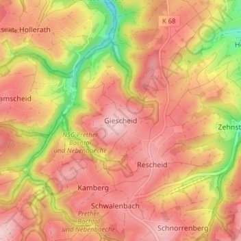
Name: Giescheid topographic map, elevation, terrain.
Average elevation: 584 m
Minimum elevation: 458 m
Maximum elevation: 654 m
Other topographic maps
Click on a map to view its topography, its elevation and its terrain.
Kehr
Deutschland > Nordrhein-Westfalen > Kreis Euskirchen > Hellenthal
Kehr, Hellenthal, Kreis Euskirchen, Nordrhein-Westfalen, 54611, Deutschland
Average elevation: 581 m
Ramscheid
Deutschland > Nordrhein-Westfalen > Kreis Euskirchen > Hellenthal
Ramscheid, Hellenthal, Kreis Euskirchen, Nordrhein-Westfalen, Deutschland
Average elevation: 596 m