
Dar Yaghmouracene topographic map
Interactive map
Click on the map to display elevation.
About this map
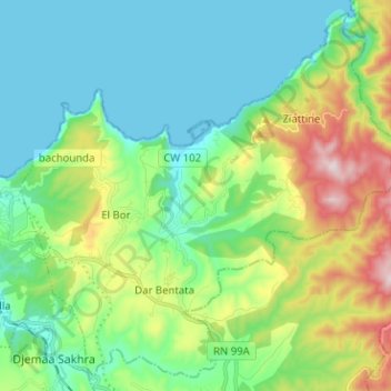
Name: Dar Yaghmouracene topographic map, elevation, terrain.
Location: Dar Yaghmouracene, Daïra Ghazaouet, Tlemcen, Algérie (35.05702 -1.83067 35.15333 -1.70418)
Average elevation: 169 m
Minimum elevation: -5 m
Maximum elevation: 620 m
Other topographic maps
Click on a map to view its topography, its elevation and its terrain.
Ghazaouet
Algérie > Tlemcen > Daïra Ghazaouet
Ghazaouet, Daïra Ghazaouet, Tlemcen, Algérie
Average elevation: 100 m
Les Orangers
Algérie > Tlemcen > Daïra Ghazaouet > Ghazaouet > Les Orangers
Les Orangers, Ghazaouet, Daïra Ghazaouet, Tlemcen, 13402, Algérie
Average elevation: 87 m