
Berneray topographic map
Interactive map
Click on the map to display elevation.
About this map
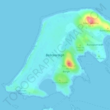
Name: Berneray topographic map, elevation, terrain.
Location: Berneray, Borve, Western Isles, Scotland, United Kingdom (57.70045 -7.22874 57.73893 -7.14385)
Average elevation: 6 m
Minimum elevation: -1 m
Maximum elevation: 91 m
Other topographic maps
Click on a map to view its topography, its elevation and its terrain.
Craigston
United Kingdom > Scotland > Western Isles > Borve
Craigston, Borve, Western Isles, Scotland, HS9 5XS, United Kingdom
Average elevation: 66 m