
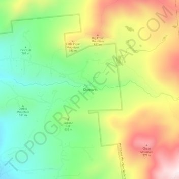
Glenmore topographic map
Interactive map
Click on the map to display elevation.
About this map
Name: Glenmore topographic map, elevation, terrain.
Average elevation: 648 m
Minimum elevation: 347 m
Maximum elevation: 1,050 m
Other topographic maps
Click on a map to view its topography, its elevation and its terrain.
Keene Valley
United States > New York > Essex County > Town of Keene
Keene Valley, Town of Keene, Essex County, New York, 12943, United States
Average elevation: 459 m
Saint Huberts
United States > New York > Essex County > Town of Keene
Saint Huberts, Town of Keene, Essex County, New York, 12943, United States
Average elevation: 536 m
Giant Mountain
United States > New York > Essex County > Town of Keene
Giant Mountain, Town of Keene, Essex County, New York, United States
Average elevation: 1,060 m
Gothics
United States > New York > Essex County > Town of Keene
Gothics, Town of Keene, Essex County, New York, United States
Average elevation: 1,095 m
Mount Marcy
United States > New York > Essex County > Town of Keene
Mount Marcy, Town of Keene, Essex County, New York, United States
Average elevation: 1,289 m