
La Grande topographic map
Interactive map
Click on the map to display elevation.
About this map
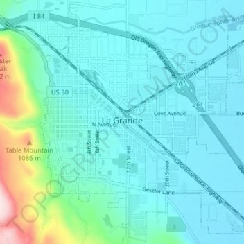
Name: La Grande topographic map, elevation, terrain.
Location: La Grande, Union County, Oregon, 97850, United States (45.30227 -118.11669 45.34612 -118.05289)
Average elevation: 887 m
Minimum elevation: 831 m
Maximum elevation: 1,201 m
Other topographic maps
Click on a map to view its topography, its elevation and its terrain.
Catherine Creek
United States > Oregon > Union County
Catherine Creek, Union County, Oregon, United States
Average elevation: 1,100 m
Perry
United States > Oregon > Union County
Perry, Union County, Oregon, United States
Average elevation: 1,112 m
Blue Mountains
United States > Oregon > Union County
Blue Mountains, Union County, Oregon, 97876, United States
Average elevation: 838 m
Spout Springs
United States > Oregon > Union County
Spout Springs, Union County, Oregon, United States
Average elevation: 1,532 m
Summerville
United States > Oregon > Union County
Summerville, Union County, Oregon, United States
Average elevation: 827 m
Elk Mountain
United States > Oregon > Union County
Elk Mountain, Union County, Oregon, United States
Average elevation: 1,518 m