
Bionaz topographic map
Interactive map
Click on the map to display elevation.
About this map
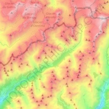
Name: Bionaz topographic map, elevation, terrain.
Location: Bionaz, Aosta Valley, Italy (45.83878 7.36458 45.98768 7.61076)
Average elevation: 2,670 m
Minimum elevation: 1,112 m
Maximum elevation: 4,145 m
Other topographic maps
Click on a map to view its topography, its elevation and its terrain.
Dent d'Hérens
Italy > Aosta Valley > Bionaz
Dent d'Hérens, Bionaz, Aosta Valley, Italy
Average elevation: 3,354 m