
Thank you for supporting this site ❤️
Make a donation
Make a donation
Atuntaqui topographic map
Click on the map to display elevation.
Thank you for supporting this site ❤️
Make a donation
Make a donation
Atuntaqui
Its capital is the town of Atuntaqui, located 10 kilometres (6.2 mi) east in straight line distance from the provincial capital of Ibarra. The province is in the Andes, the capital at an elevation of 2,405 metres (7,890 ft) above sea level.
Thank you for supporting this site ❤️
Make a donation
Make a donation
About this map
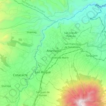
Name: Atuntaqui topographic map, elevation, terrain.
Location: Atuntaqui, Imbabura, Ecuador (0.25417 -78.24632 0.40204 -78.13345)
Average elevation: 2,544 m
Minimum elevation: 1,817 m
Maximum elevation: 4,567 m
Thank you for supporting this site ❤️
Make a donation
Make a donation
Other topographic maps
Click on a map to view its topography, its elevation and its terrain.
Thank you for supporting this site ❤️
Make a donation
Make a donation
Thank you for supporting this site ❤️
Make a donation
Make a donation