
Make a donation
Lich-Steinstraß topographic map
Click on the map to display elevation.
Make a donation
About this map
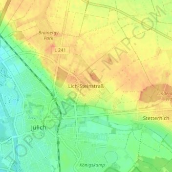
Name: Lich-Steinstraß topographic map, elevation, terrain.
Average elevation: 96 m
Minimum elevation: 76 m
Maximum elevation: 115 m
Make a donation
Other topographic maps
Click on a map to view its topography, its elevation and its terrain.
Stetternich
Deutschland > Nordrhein-Westfalen > Kreis Düren > Jülich
Stetternich liegt in der Jülich-Zülpicher Börde westlich der Sophienhöhe. Im Norden und Osten wird der Ort vom Lindenberger Wald umgeben. Im Süden und Westen verlaufen der Mühlengraben und der Ellebach. Etwa 1 km südlich von Stetternich im Selgenbusch liegt das Forschungszentrum Jülich. Nachbarorte…
Average elevation: 100 m
Güsten
Deutschland > Nordrhein-Westfalen > Kreis Düren > Jülich
Im Westen liegt Welldorf, im Norden der Wohnplatz Serrest, im Osten Rödingen (Gemeinde Titz) und im Süden der Tagebau Hambach mit der Sophienhöhe. Die Bebauung von Güsten und Welldorf geht fast nahtlos ineinander über.
Average elevation: 125 m
52428
Deutschland > Nordrhein-Westfalen > Kreis Düren > Jülich > Lich-Steinstraß
Average elevation: 98 m
Make a donation
Brückenkopfpark
Deutschland > Nordrhein-Westfalen > Kreis Düren > Jülich > Koslar
Der Brückenkopf ist als Kronwerk ausgelegt und weist eine Breite von etwa 800 Metern, eine Tiefe von etwa 300 Metern und eine Höhe von etwa zehn Metern auf. Er besteht im Wesentlichen aus mit Mauern abgestütztem Erdreich. Auf dem Wall befinden sich tonnengewölbte Hohltraversen zur Aufstellung von…
Average elevation: 83 m
Welldorf
Deutschland > Nordrhein-Westfalen > Kreis Düren > Jülich
Im Westen liegt Lich-Steinstraß, im Norden Spiel (Gemeinde Titz), im Osten Güsten und im Süden der Tagebau Hambach mit der Sophienhöhe. Die Bebauung von Güsten und Welldorf geht fast nahtlos ineinander über.
Average elevation: 121 m
Make a donation