
北翠 topographic map
Interactive map
Click on the map to display elevation.
About this map
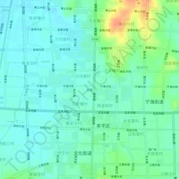
Name: 北翠 topographic map, elevation, terrain.
Location: 北翠, 宁海街道, 牟平区, 烟台市, 山东省, 264100, 中国 (37.37506 121.57173 37.41506 121.61173)
Average elevation: 13 m
Minimum elevation: 2 m
Maximum elevation: 43 m
Other topographic maps
Click on a map to view its topography, its elevation and its terrain.
烟台牟平山昔山-昆嵛山-大沽夹河-沁水河生物多样性维护生态保护I类红线区
烟台牟平山昔山-昆嵛山-大沽夹河-沁水河生物多样性维护生态保护I类红线区, 环岛路, 宁海街道, 牟平区, 烟台市, 山东省, 264100, 中国
Average elevation: 8 m