
Thank you for supporting this site ❤️
Make a donation
Make a donation
Lac Malo topographic map
Click on the map to display elevation.
Thank you for supporting this site ❤️
Make a donation
Make a donation
About this map
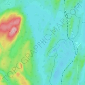
Name: Lac Malo topographic map, elevation, terrain.
Average elevation: 425 m
Minimum elevation: 389 m
Maximum elevation: 557 m
Thank you for supporting this site ❤️
Make a donation
Make a donation
Other topographic maps
Click on a map to view its topography, its elevation and its terrain.
Thank you for supporting this site ❤️
Make a donation
Make a donation
Thank you for supporting this site ❤️
Make a donation
Make a donation
Thank you for supporting this site ❤️
Make a donation
Make a donation
Rivière de la Licorne
Canada > Québec > Le Domaine-du-Roy > Lac-Ashuapmushuan
Average elevation: 419 m
Thank you for supporting this site ❤️
Make a donation
Make a donation
Thank you for supporting this site ❤️
Make a donation
Make a donation