
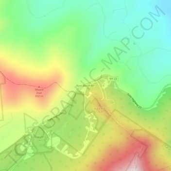
East Windham topographic map
Interactive map
Click on the map to display elevation.
About this map
Name: East Windham topographic map, elevation, terrain.
Average elevation: 556 m
Minimum elevation: 252 m
Maximum elevation: 993 m
Other topographic maps
Click on a map to view its topography, its elevation and its terrain.
Cornwallville
United States > New York > Greene County > Town of Durham
Cornwallville, Town of Durham, Greene County, New York, 12418, United States
Average elevation: 327 m
East Durham
United States > New York > Greene County > Town of Durham
East Durham, Town of Durham, Greene County, New York, United States
Average elevation: 211 m
Sunside
United States > New York > Greene County > Town of Durham
Sunside, Town of Durham, Greene County, New York, 12405, United States
Average elevation: 205 m
Oak Hill
United States > New York > Greene County > Town of Durham
Oak Hill, Town of Durham, Greene County, New York, 12460, United States
Average elevation: 240 m
Durso Corner
United States > New York > Greene County > Town of Durham
Durso Corner, Town of Durham, Greene County, New York, 12418, United States
Average elevation: 435 m
Hervey Street
United States > New York > Greene County > Town of Durham
Hervey Street, Town of Durham, Greene County, New York, 12418, United States
Average elevation: 363 m
West Durham
United States > New York > Greene County > Town of Durham
West Durham, Town of Durham, Greene County, New York, 12422, United States
Average elevation: 539 m