
Thank you for supporting this site ❤️
Make a donation
Make a donation
Houesville topographic map
Click on the map to display elevation.
Thank you for supporting this site ❤️
Make a donation
Make a donation
About this map
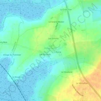
Name: Houesville topographic map, elevation, terrain.
Average elevation: 12 m
Minimum elevation: -2 m
Maximum elevation: 35 m
Thank you for supporting this site ❤️
Make a donation
Make a donation
Other topographic maps
Click on a map to view its topography, its elevation and its terrain.
Le Haut de l'Amont
France > Normandie > Manche > Carentan-les-Marais > Saint-Côme-du-Mont
Average elevation: 7 m