
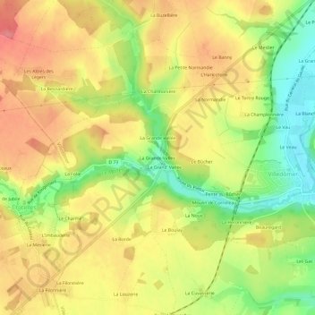
La Grande Vallée topographic map
Interactive map
Click on the map to display elevation.
About this map
Name: La Grande Vallée topographic map, elevation, terrain.
Average elevation: 121 m
Minimum elevation: 75 m
Maximum elevation: 156 m
Other topographic maps
Click on a map to view its topography, its elevation and its terrain.
La Grande Vallée
France > Centre-Val de Loire > Indre-et-Loire > Villedômer
La Grande Vallée, Villedômer, Loches, Indre-et-Loire, Centre-Val de Loire, France métropolitaine, 37110, France
Average elevation: 122 m
Le Boulay
France > Centre-Val de Loire > Indre-et-Loire > Villedômer > Le Boulay
Le Boulay, Villedômer, Loches, Indre-et-Loire, Centre-Val de Loire, France métropolitaine, 37110, France
Average elevation: 118 m
La Grand’ Vallée
France > Centre-Val de Loire > Indre-et-Loire > Villedômer > La Grand’ Vallée
La Grand’ Vallée, Villedômer, Loches, Indre-et-Loire, Centre-Val de Loire, France métropolitaine, 37110, France
Average elevation: 120 m