Geolocate

沙东乡 topographic map

Interactive map

Click on the map to display elevation.

About this map

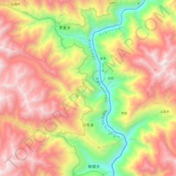
Name: 沙东乡 topographic map, elevation, terrain.

Location: 沙东乡, 贡觉县, 昌都市, 西藏自治区, 中国 (30.59081 98.74379 30.70453 98.94142)

Average elevation: 3,879 m

Minimum elevation: 2,631 m

Maximum elevation: 5,075 m

Other topographic maps

Click on a map to view its topography, its elevation and its terrain.

相皮乡

中国 > 西藏自治区 > 贡觉县

相皮乡, 贡觉县, 昌都市, 西藏自治区, 中国

Average elevation: 4,250 m

莫洛镇

中国 > 西藏自治区 > 贡觉县

莫洛镇, 贡觉县, 昌都市, 西藏自治区, 中国

Average elevation: 4,241 m

罗麦乡

中国 > 西藏自治区 > 贡觉县

罗麦乡, 贡觉县, 昌都市, 西藏自治区, 中国

Average elevation: 4,027 m

则巴乡

中国 > 西藏自治区 > 贡觉县

则巴乡, 贡觉县, 昌都市, 西藏自治区, 中国

Average elevation: 4,253 m

阿旺乡

中国 > 西藏自治区 > 贡觉县

阿旺乡, 贡觉县, 昌都市, 西藏自治区, 中国

Average elevation: 4,375 m

哈加乡

中国 > 西藏自治区 > 贡觉县

哈加乡, 贡觉县, 昌都市, 西藏自治区, 中国

Average elevation: 4,212 m