
Jambi topographic map
Interactive map
Click on the map to display elevation.
About this map
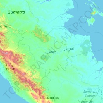
Name: Jambi topographic map, elevation, terrain.
Location: Jambi, Indonesia (-2.78226 101.12256 -0.50888 105.01221)
Average elevation: 149 m
Minimum elevation: -3 m
Maximum elevation: 3,657 m
Other topographic maps
Click on a map to view its topography, its elevation and its terrain.
Mount Kerinci
Indonesia > Jambi > Sungai Penuh
Mount Kerinci, Sungai Penuh, Kecamatan Serai Serumpun, Jambi, Indonesia
Average elevation: 3,229 m