
Town of Gilboa topographic map
Interactive map
Click on the map to display elevation.
About this map
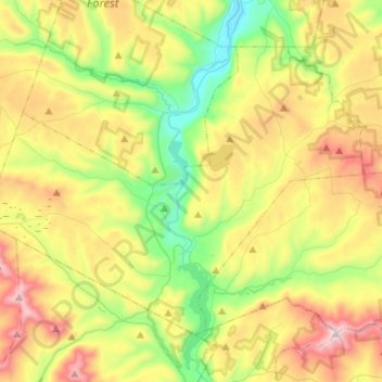
Name: Town of Gilboa topographic map, elevation, terrain.
Location: Town of Gilboa, Schoharie County, New York, United States (42.35510 -74.58933 42.50199 -74.32602)
Average elevation: 541 m
Minimum elevation: 215 m
Maximum elevation: 1,031 m
Other topographic maps
Click on a map to view its topography, its elevation and its terrain.
Flat Creek
United States > New York > Schoharie County > Town of Gilboa
Flat Creek, Town of Gilboa, Schoharie County, New York, 12076, United States
Average elevation: 557 m
Mine Kill State Park
United States > New York > Schoharie County > Town of Gilboa
Mine Kill State Park, Town of Gilboa, Town of Blenheim, Schoharie County, New York, United States
Average elevation: 352 m