
Thank you for supporting this site ❤️
Make a donation
Make a donation
Paccha topographic map
Click on the map to display elevation.
Thank you for supporting this site ❤️
Make a donation
Make a donation
About this map
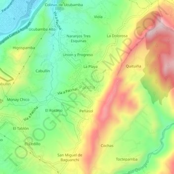
Name: Paccha topographic map, elevation, terrain.
Location: Paccha, Cuenca, Azuay, 010109, Ecuador (-2.91985 -78.95472 -2.87985 -78.91472)
Average elevation: 2,610 m
Minimum elevation: 2,412 m
Maximum elevation: 2,879 m
Thank you for supporting this site ❤️
Make a donation
Make a donation
Other topographic maps
Click on a map to view its topography, its elevation and its terrain.