
阿克旗乡 topographic map
Interactive map
Click on the map to display elevation.
About this map
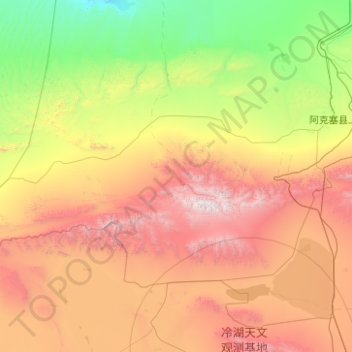
Name: 阿克旗乡 topographic map, elevation, terrain.
Location: 阿克旗乡, 阿克塞哈萨克族自治县, 酒泉市, 甘肃省, 736400, 中国 (38.89437 92.33865 39.86930 94.33146)
Average elevation: 2,407 m
Minimum elevation: 873 m
Maximum elevation: 5,739 m
Other topographic maps
Click on a map to view its topography, its elevation and its terrain.
阿克塞县
中国 > 甘肃省 > 阿克塞哈萨克族自治县 > 红柳湾镇
阿克塞县, 红柳湾镇, 阿克塞哈萨克族自治县, 酒泉市, 甘肃省, 736400, 中国
Average elevation: 1,824 m
红崖子
中国 > 甘肃省 > 阿克塞哈萨克族自治县 > 阿勒腾乡
红崖子, 阿勒腾乡, 阿克塞哈萨克族自治县, 酒泉市, 甘肃省, 736400, 中国
Average elevation: 3,711 m
东格列克村
中国 > 甘肃省 > 阿克塞哈萨克族自治县 > 阿克旗乡
东格列克村, 阿克旗乡, 阿克塞哈萨克族自治县, 酒泉市, 甘肃省, 736400, 中国
Average elevation: 1,686 m