
Ödemiş topographic map
Interactive map
Click on the map to display elevation.
About this map
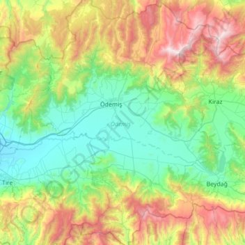
Name: Ödemiş topographic map, elevation, terrain.
Location: Ödemiş, Izmir, Aegean Region, 35750, Turkey (37.96578 27.78269 38.41857 28.19648)
Average elevation: 663 m
Minimum elevation: 42 m
Maximum elevation: 2,145 m
Other topographic maps
Click on a map to view its topography, its elevation and its terrain.
Ayvacık Yaylası
Turkey > Ödemiş > Ayvacık Yaylası
Ayvacık Yaylası, Ödemiş, Izmir, Aegean Region, Turkey
Average elevation: 930 m