
Edinborough topographic map
Interactive map
Click on the map to display elevation.
About this map
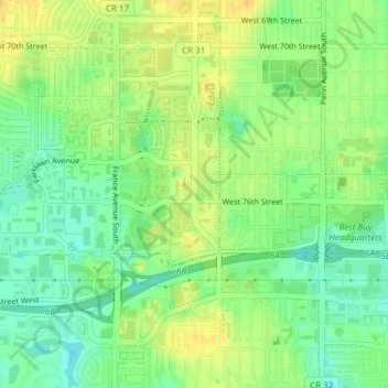
Name: Edinborough topographic map, elevation, terrain.
Average elevation: 261 m
Minimum elevation: 247 m
Maximum elevation: 273 m
Other topographic maps
Click on a map to view its topography, its elevation and its terrain.
Fred Richards Park
United States > Minnesota > Hennepin County > Edina
Fred Richards Park, Edina, Hennepin County, Minnesota, 55435, United States
Average elevation: 259 m