
Thank you for supporting this site ❤️
Make a donation
Make a donation
Meãs do Campo topographic map
Click on the map to display elevation.
Thank you for supporting this site ❤️
Make a donation
Make a donation
About this map
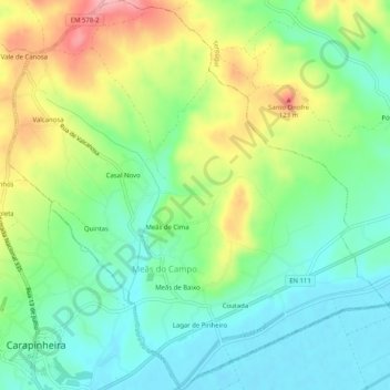
Name: Meãs do Campo topographic map, elevation, terrain.
Location: Meãs do Campo, Montemor-o-Velho, Coimbra, Portugal (40.20131 -8.65200 40.24005 -8.60253)
Average elevation: 47 m
Minimum elevation: 1 m
Maximum elevation: 128 m
Thank you for supporting this site ❤️
Make a donation
Make a donation
Other topographic maps
Click on a map to view its topography, its elevation and its terrain.
Thank you for supporting this site ❤️
Make a donation
Make a donation
Thank you for supporting this site ❤️
Make a donation
Make a donation