
Make a donation
Canary Islands topographic map
Click on the map to display elevation.
Make a donation
Canary Islands
The Canary Islands, especially Tenerife, Gran Canaria, Fuerteventura, and Lanzarote, are a major tourist destination, with over 12 million visitors per year. This is due to their beaches, subtropical climate, and important natural attractions, especially Maspalomas in Gran Canaria and Mount Teide (a World Heritage Site) in Tenerife. Mount Teide is the highest peak in Spain and the 4th tallest volcano in the world, measured from its base on the ocean floor. The islands have warm summers and winters warm enough for the climate to be technically tropical at sea level. The amount of precipitation and the level of maritime moderation vary depending on location and elevation. The archipelago includes green areas as well as desert. The islands' high mountains are ideal for astronomical observation, because they lie above the temperature inversion layer. As a result, the archipelago boasts two professional observatories: the Teide Observatory on Tenerife, and Roque de los Muchachos Observatory on La Palma.
Make a donation
About this map
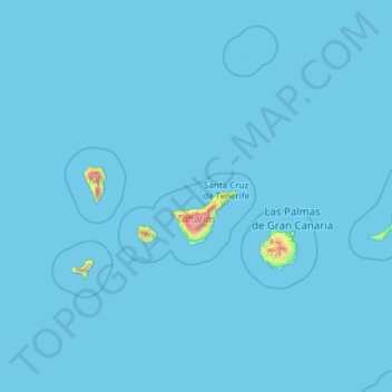
Name: Canary Islands topographic map, elevation, terrain.
Location: Canary Islands, Spain (27.63774 -18.16118 29.41606 -13.33201)
Average elevation: 16 m
Minimum elevation: 0 m
Maximum elevation: 3,500 m
Make a donation
Other topographic maps
Click on a map to view its topography, its elevation and its terrain.
Pamplona
Spain > Navarre > Iruñerria / Comarca de Pamplona
The climate of Pamplona is classified as an oceanic climate (Köppen climate classification: Cfb) with influences of a Mediterranean climate (Csb). Due to global warming and stronger summer heat waves in the 21st century, it is also on the boundary with a humid subtropical climate (Cfa). Precipitation patterns…
Average elevation: 611 m
Make a donation
Alhambra
Spain > Andalusia > Comarca de la Vega de Granada > Granada
During the reign of the Nasrid Dynasty, the Alhambra was transformed into a palatine city, complete with an irrigation system composed of aqueducts and water channels that provided water for the complex and for other nearby countryside palaces such as the Generalife. Previously, the old fortresses on the hill…
Average elevation: 759 m
Make a donation