
Belle Grove Square topographic map
Interactive map
Click on the map to display elevation.
About this map
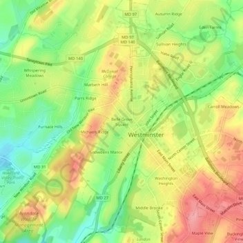
Name: Belle Grove Square topographic map, elevation, terrain.
Average elevation: 224 m
Minimum elevation: 173 m
Maximum elevation: 274 m
Other topographic maps
Click on a map to view its topography, its elevation and its terrain.
Washington Heights
United States > Maryland > Carroll County > Westminster
Washington Heights, Westminster, Carroll County, Maryland, 21157, United States
Average elevation: 233 m