
Caldwell topographic map
Interactive map
Click on the map to display elevation.
About this map
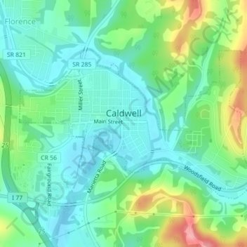
Name: Caldwell topographic map, elevation, terrain.
Location: Caldwell, Noble County, Ohio, United States (39.73848 -81.53135 39.75481 -81.49839)
Average elevation: 247 m
Minimum elevation: 215 m
Maximum elevation: 324 m
Other topographic maps
Click on a map to view its topography, its elevation and its terrain.
Batesville
United States > Ohio > Noble County
Batesville, Noble County, Ohio, United States
Average elevation: 308 m
Belle Valley
United States > Ohio > Noble County > Belle Valley
Belle Valley, Noble County, Ohio, 43717, United States
Average elevation: 251 m
Mount Zion
United States > Ohio > Noble County > Mount Zion
Mount Zion, Noble County, Ohio, 43772, United States
Average elevation: 274 m
Flag
United States > Ohio > Noble County
Flag, Noble County, Ohio, 43786, United States
Average elevation: 278 m