
Tehran topographic map
Interactive map
Click on the map to display elevation.
Tehran
As the city has a large area, with significant differences in elevation among various districts, the weather is often cooler in the hilly north than in the flat southern part of Tehran. For instance, the 17.3 km (10.7 mi) Valiasr Street runs from Tehran's railway station at 1,117 m (3,665 ft) elevation above sea level in the south of the city to Tajrish Square at 1712.6 m (5612.3 ft) elevation above sea level in the north. However, the elevation can even rise up to 2,000 m (6,600 ft) at the end of Velenjak in northern Tehran. The sparse texture, the existence of old gardens, orchards, green spaces along the highways and the lack of industrial activities in the north of the city have helped the air in the northern areas to be 2 to 3 degrees Celsius cooler than the southern areas of the city.
About this map
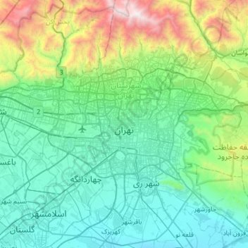
Name: Tehran topographic map, elevation, terrain.
Average elevation: 1,539 m
Minimum elevation: 976 m
Maximum elevation: 3,943 m