
Make a donation
Boise topographic map
Click on the map to display elevation.
Make a donation
Boise
Boise (locally /ˈbɔɪsi/ BOY-see) is the capital and most populous city of the U.S. state of Idaho. The population was 235,685 at the 2020 census. The Boise metropolitan area, also known as the Treasure Valley, includes five counties with an estimated population of 846,000, the most populous metropolitan area in Idaho and 74th-most populous in the United States. Located on the Boise River in southwestern Idaho, it is 41 miles (66 km) east of the Oregon border and 110 miles (177 km) north of the Nevada border. Downtown Boise's elevation is 2,704 feet (824 m) above sea level. It is the county seat of Ada County.
Make a donation
About this map
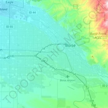
Name: Boise topographic map, elevation, terrain.
Location: Boise, Ada County, Idaho, United States (43.50218 -116.36568 43.69206 -116.09419)
Average elevation: 970 m
Minimum elevation: 779 m
Maximum elevation: 1,863 m
Make a donation
Other topographic maps
Click on a map to view its topography, its elevation and its terrain.
Boise
United States > Idaho > Ada County
Boise (locally /ˈbɔɪsi/ BOY-see) is the capital and most populous city of the U.S. state of Idaho and is the county seat of Ada County. As of the 2020 census, there were 235,684 people residing in the city. On the Boise River in southwestern Idaho, it is 41 miles (66 km) east of the Oregon border and 110…
Average elevation: 1,040 m
Make a donation