
Centreville topographic map
Interactive map
Click on the map to display elevation.
About this map
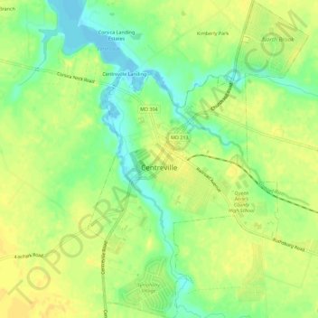
Name: Centreville topographic map, elevation, terrain.
Location: Centreville, Queen Anne's County, Maryland, United States (39.02143 -76.08002 39.06485 -76.04112)
Average elevation: 15 m
Minimum elevation: -2 m
Maximum elevation: 24 m
Other topographic maps
Click on a map to view its topography, its elevation and its terrain.
Kent Island
United States > Maryland > Queen Anne's County > Chester
Kent Island, Chester, Queen Anne's County, Maryland, United States
Average elevation: 1 m
Tuckahoe State Park
United States > Maryland > Queen Anne's County > Waljacks Corners
Tuckahoe State Park, Queen Anne Highway, Waljacks Corners, Queen Anne's County, Maryland, 21657, United States
Average elevation: 17 m
Chester
United States > Maryland > Queen Anne's County > Chester
Chester, Queen Anne's County, Maryland, United States
Average elevation: 2 m
Stevensville
United States > Maryland > Queen Anne's County
Stevensville, Queen Anne's County, Maryland, United States
Average elevation: 2 m
Grasonville
United States > Maryland > Queen Anne's County
Grasonville, Queen Anne's County, Maryland, 21638, United States
Average elevation: 3 m