
Grüner See topographic map
Interactive map
Click on the map to display elevation.
About this map
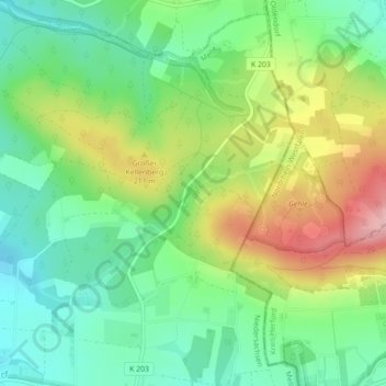
Name: Grüner See topographic map, elevation, terrain.
Average elevation: 160 m
Minimum elevation: 94 m
Maximum elevation: 269 m
Other topographic maps
Click on a map to view its topography, its elevation and its terrain.
Ostenfelde
Deutschland > Niedersachsen > Melle > Neuenkirchen > Ostenfelde
Ostenfelde, Neuenkirchen, Melle, Landkreis Osnabrück, Niedersachsen, Deutschland
Average elevation: 100 m
Schloss Gesmold
Deutschland > Niedersachsen > Melle
Schloss Gesmold, A 30, Gesmold, Melle, Landkreis Osnabrück, Niedersachsen, 49326, Deutschland
Average elevation: 82 m